Best Surveying Drones in Canada 2026: Top 5 Picks
Published on Saturday, January 24, 2026
Surveying drones are used for land surveys, mapping, and site assessments, significantly improving efficiency and accuracy in data collection. In Canada, surveyors, engineering firms, environmental consultants, and resource managers choose drones for their ability to capture high-resolution imagery and lidar data quickly across large and remote areas. Canadian buyers prioritize rugged hardware that performs in cold or wet conditions, integrated RTK/PPK positioning for centimetre-level accuracy, long battery life, sensor flexibility (photogrammetry, multispectral, LiDAR), and strong software and service support that meets Transport Canada rules for commercial operations. The result is faster project delivery, lower field time and safety risks, and richer datasets for planning, permitting, and monitoring across industries such as civil construction, mining, forestry, agriculture, and utilities.
Top Picks Summary
DJI Matrice 350 RTK
The Matrice 350 RTK is a market-leading enterprise platform for surveying that combines long endurance, industrial-grade build (IP45) and flexible multi-payload support, making it ideal for complex, repeatable mapping workflows. It justifies a higher upfront cost through reduced mission cycles and the ability to carry LiDAR and high-resolution photogrammetry sensors simultaneously, outperforming smaller platforms in payload versatility and mission throughput. For survey teams needing a single, rugged workhorse across varied sites, it delivers technical depth and workflow efficiencies that cheaper quadcopters on this list cannot match.
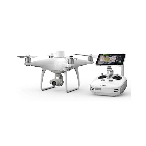
DJI Phantom 4 RTK
The Phantom 4 RTK is a proven, cost-effective surveying drone that offers integrated RTK-level positioning with a calibrated camera, making it a favorite for small-to-medium site photogrammetry. Its lower acquisition cost and straightforward workflow make it more affordable per project than the Matrice or fixed-wing options, though it lacks the Matrice's payload flexibility and the eBee X's large-area endurance. For teams focused on tight budgets and precise orthomosaic requirements, it often represents the best value-to-performance balance on this list.
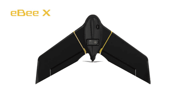
senseFly eBee X
The senseFly eBee X is a fixed-wing survey specialist that excels at high-area productivity, providing industry-leading flight endurance and cost-per-hectare efficiency for large-scale mapping campaigns. Compared with the multirotor entries here, the eBee X drastically reduces flight counts and operational time for wide-area surveys, although it trades VTOL and close-quarters agility for efficiency and maximum coverage per sortie. Organizations working on large cadastral, agricultural or environmental surveys will find its economics and sensor options particularly compelling.
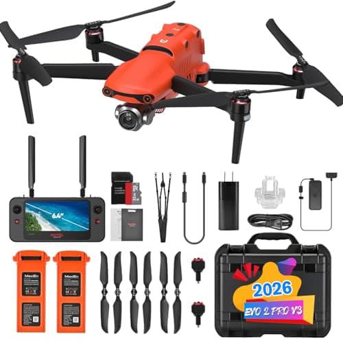
Autel EVO II Pro RTK
The Autel EVO II Pro RTK offers a strong combination of high-resolution imaging, integrated RTK, and a competitive price point, positioning it as a high-value alternative to the major OEM offerings. It narrows the gap on technical capability—delivering 1"-class sensor performance and precise geotagging—while often undercutting equivalent DJI enterprise models on purchase cost and supply-chain diversity. Survey teams seeking comparable photogrammetric quality with lower capital outlay or vendor redundancy benefits will find the EVO II Pro RTK attractive.
DJI Mavic 3 Enterprise
The Mavic 3 Enterprise brings professional RTK-capable surveying into a compact, ultra-portable package, enabling fast deployment and efficient small-site data capture with high-quality optics. It sits between the Phantom and Matrice in price and capability: cheaper and more portable than the Matrice, yet more capable and rugged than consumer models, though it cannot match fixed-wing endurance or the Matrice's payload flexibility. For surveyors prioritizing mobility, rapid response, and decent surveying precision without the bulk of larger platforms, it is the most practical choice on this list.
$6,000-12,000 CAD
Scientific evidence and practical benefits
Multiple peer-reviewed studies and industry reports show that unmanned aerial systems improve mapping speed, maintain or increase positional accuracy when using RTK/PPK workflows, and reduce field labor and safety exposure compared with traditional ground surveys. Research published in journals such as Remote Sensing and the International Journal of Applied Earth Observation and Geoinformation, along with government and university reports, documents real-world gains in data resolution, repeatability, and cost-effectiveness when drones are paired with established photogrammetry or LiDAR processing workflows.
Accuracy: RTK and PPK-equipped drones routinely achieve centimetre-level horizontal and vertical accuracy for many mapping tasks, reducing the need for dense ground control points in many workflows.
Speed and cost: Case studies report time savings of 50 percent or more on site data collection and lower overall project costs because airborne surveys cover large areas faster than manual methods.
Safety and access: Drones reduce safety exposure by replacing work in hazardous or hard-to-access terrain while enabling repeated monitoring without additional field visits.
Sensor flexibility: Combining photogrammetry, multispectral imaging, and lidar supports diverse applications from topographic mapping to vegetation analysis and volumetrics.
Limitations: Performance depends on weather, operator skill, and processing workflows; the highest precision still benefits from good control, calibration, and postprocessing.
Frequently Asked Questions
Should I buy the DJI Matrice 350 RTK for surveying?
Choose the DJI Matrice 350 RTK if you need repeatable, complex mapping with multi-payload support; it has an industrial-grade IP45 build and a 4.8 average rating, plus redundant flight systems and long endurance for safer missions, backed by a warranty duration not provided.
What exact RTK accuracy does DJI Matrice 350 RTK offer?
The DJI Matrice 350 RTK includes industrial-grade RTK with sub-centimetre positioning for high-precision surveys, with an average rating of 4.8; the listing does not provide payload compatibility beyond LiDAR/multispectral/thermal support or any warranty duration.
How does the DJI Matrice 350 RTK price compare for mapping?
The DJI Matrice 350 RTK is listed at $790.51 CADand includes IP45 industrial-grade build, redundant flight systems, and multi-payload support (LiDAR, multispectral, thermal); the listing doesn’t state what you get beyond those specs, or include warranty duration.
Which drone is best for large-scale surveying flights, senseFly eBee X?
For large-scale mapping campaigns, the senseFly eBee X uses a fixed-wing platform for long endurance and high-area coverage per sortie, with a 4.7 average rating; it also supports modular RGB/multispectral/thermal payloads with PPK/RTK, and warranty duration isn’t listed.
Conclusion
In Canada, choosing the right surveying drone depends on scale, sensor needs, and operating conditions. The DJI Matrice 350 RTK stands out as the best overall choice for enterprise survey work because of its modular payloads, robust RTK performance, and durable design. The DJI Phantom 4 RTK remains a cost-effective photogrammetry workhorse for many mapping teams. The senseFly eBee X is ideal for large-area fixed-wing mapping where flight time and coverage matter. The Autel EVO II Pro RTK offers a strong balance of image quality and portability with RTK precision, and the DJI Mavic 3 Enterprise is a compact, powerful option for tight sites and quick inspections. I hope you found what you were looking for; use the search to refine or expand your results by sensor type, budget, or application to find the best surveying drone for your Canadian projects.